Seismic refraction tomography is a geophysical prospecting technique that allows the determination of the geological and geotechnical characteristics of the soil, being one of the most used methods for the analysis of land, this method is very useful for various areas such as geology, geotechnics, civil engineering and construction. This technique makes it possible to obtain flat longitudinal sections of the subsoil, which allow the different levels of the ground to be identified based on the relationship between the speed of propagation of the waves and the geotechnical characteristics of the soil. This method is especially effective for the determination of alluvium and sediment thicknesses.
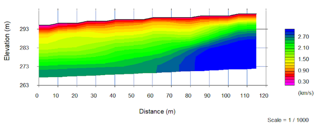
Refraction tomography (Figure 1) provides data on the speed of the primary waves (P or S), depending on the method used, as well as data on the depth below each geophone. This allows the seismic classification of the soil based on the speed of propagation of the waves, allowing precise longitudinal cuts to be made on the thickness of the sedimentary cover and the depth of the rocky basement. Through this technique it is possible to identify the degree of alteration of the materials that make up the subsoil, the degree of fracture of the rock, detect faults and geological fractures, as well as areas of possible landslides, the level of compaction of the sediments, among other applications.
This method is based on the propagation of artificially produced seismic waves, establishing their relationship with the geological configuration of the soil. It consists of making longitudinal profiles with sensors (geophones), spaced from each other at a predetermined distance. This measures the time in which a compression or shear seismic wave arrives through the geological environment to the different sensors distributed in the prospecting line. The speed with which the wave propagates in the subsoil will depend on the type of soil it is passing through.
Some applications of refraction tomography:
- Determination of the depth of rocky basement.
- Determination of soil conditions such as: weathering, fracturing level and rock competition.
- Detection of geological faults and other structures.
- Stratigraphic characterization of the soil, determination of the depth and thickness of the different layers and their morphology.
- Geomechanical classification of rock.
- Definition of various geotechnical parameters such as fracture rate (RQD), density, porosity, etc.
- Seismic risk assessment.
- Rock rippability.
- Determination of deformation modules (in conjunction with methods of determining Vs).
Figure 1: Example of refraction tomography.