The vertical electrical sounding or geoelectric method is one of the most used electrical geophysical techniques thanks to its simplicity and relative low cost. These are especially useful in hydrogeological studies where it is necessary to define and characterize deep phreatic levels. Vertical electrical sounding or SEV are a geophysical technique that, by means of electricity, allows recognizing or distinguishing the different geological formations that are found in depth and delimiting them. Electrical or electromagnetic geophysical techniques are based on measuring the resistivity of materials or conductivity.
Vertical Electrical Sounding (VES) is a one-dimensional direct current electrical resistivity method, which consists of introducing a continuous electrical current of known intensity into the ground through two or more emitting electrodes, commonly called A and B, and measuring the electric potential difference using another pair of receiving electrodes, M and N, in this way it is possible to obtain the induced potential and the vertical distribution of the resistivities of the traversed formations. Using this method, the depth of study is directly proportional to the distance between the current electrodes and/or the potential electrodes used, so that the greater the separation distance between the electrodes, the greater the depth of the soil to be studied, while a spacing between the electrodes will measure the resistivity distribution in the subsurface at shallower depths. In this method, the results are compared with the common resistivities of the different materials, which allows them to be differentiated from each other.
The current injection electrodes A and B, and the potential measurement electrodes M and N, are arranged aligned in a certain structure, for this different configurations called “electrode device” are used, some of the most used are the Schlumberger configuration , Wenner and Dipole-Dipole.
Some of the SEV applications are:
- Determine geological limits.
- Determine the geoelectric stratification of the subsoil.
- Characterization of aquifers.
- Study of the level of contamination of an aquifer.
- Distinguish between different sedimentary formations.
- Detection of mineral mass that respond by their resistivity contrast.
- Determination of bedrock.
- Identification of the resistivity of the subsoil for grounding.
- Definition of geological structures distinguishable by their resistivity.
- Quarry study.
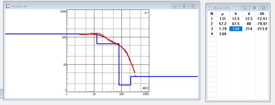
Figure 1: Geoelectrical data processing result through the IPI2WIN software.