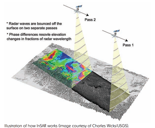
Interferometry with Synthetic Aperture Radar (InSAR) is a technique used to measure the movement of the earth’s surface through the phase difference of electromagnetic waves sent by satellites. Unlike visible or infrared light, radar waves penetrate most clouds and are equally effective in the dark, therefore the InSAR technique is effective even during bad weather and at night (very important advantage during volcanic eruptions) . This technique is based on the study and comparison of the interference pattern of two SAR images (synthetic aperture radars) taken at different times. The resulting interference pattern or interferogram is used to generate displacement maps of the Earth’s surface. To date, InSAR is the only technique that allows measuring the movement of areas of hundreds of km2 with uncertainties ranging from 5 cm at rates of 1 mm/year.
InSAR can also be used to build land surface elevation models (DEMs), using stereoscopic effects caused by subtle differences between observed positions of two SAR images.
Some applications of the InSAR technique are:
- Monitoring of fault zones and landslides
- Monitoring of volcanic eruptions.
- Surveillance of subsidence and structural stability
- Glaciology